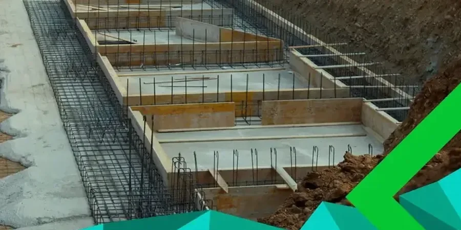
IBC Chapter 18 and ASCE 7 set the baseline, but in Springfield the real challenge is what sits beneath the topsoil. The city rests on Mississippian-age limestone of the Burlington-Keokuk formation, weathered into a mantle of stiff red clay with chert fragments — what local drillers call 'red clay and chat'. That material controls bearing capacity and heave potential. Section 1806 of the IBC demands a site-specific investigation when presumptive values fall outside code tables. We find that happens routinely here, especially south of James River Freeway where the clay thickness varies from 4 to 20 feet across a single lot. Before setting footing dimensions, we often cross-check stratigraphy with test pits to map bedrock depth and confirm refusal conditions without waiting for drill rig mobilization.
In Springfield's karst terrain, the difference between a $2,000 footing and a $15,000 repair is often one missed test boring through the clay-to-rock transition.
Our approach and scope
Local considerations
Springfield sits at 1,299 feet elevation on the Springfield Plateau, a sub-region of the Ozarks characterized by solution-weathered limestone. The U.S. Geological Survey has mapped dozens of sinkholes within city limits — some active, some paleo-collapse features hidden under 10 feet of residuum. A shallow foundation placed over a soil-filled fissure or incipient sinkhole can experience sudden differential settlement that no standard factor of safety captures. IBC 1803.5.12 mandates karst evaluation for critical structures, but even residential and light commercial projects benefit from a basic reconnaissance: mapping closed depressions, running a few deeper borings, and cross-checking with Greene County sinkhole inventory data. The cost of ignoring karst features far exceeds the cost of a targeted investigation.
Relevant standards
IBC 2021 – Chapter 18 (Soils and Foundations), ASCE/SEI 7-22 – Minimum Design Loads, ASTM D1586 – Standard Penetration Test, ASTM D2487 – USCS Soil Classification, ASTM D1194 – Plate Load Test (where applicable)
Complementary services
Site characterization
Borings, test pits, and CPT profiling to establish soil stratigraphy, bedrock depth, and groundwater conditions per IBC 1803.
Bearing capacity analysis
Ultimate and allowable bearing pressure calculations using Vesic, Terzaghi, and Meyerhof methods, corrected for local clay behavior observed in lab testing.
Settlement evaluation
Immediate and consolidation settlement estimates using Schmertmann and Janbu methods, with field-measured modulus values from SPT and CPT data.
Karst mitigation design
Sinkhole risk screening, geophysical reconnaissance when warranted, and foundation recommendations for sites with documented karst features.
Typical parameters
Common questions
What is the typical cost range for a shallow foundation design report in Springfield?
For a standard single-family or light commercial lot, the geotechnical investigation and foundation design report typically falls between US$1,700 and US$3,540. The final cost depends on the number of borings required, lab testing scope, and whether karst features trigger additional geophysical survey work.
How deep do footings need to be in Springfield, Missouri?
IBC Table 1809.5 specifies a minimum 18-inch embedment for frost protection in this region. In practice, many Springfield sites require 24 to 36 inches to reach competent clay below the organic topsoil and weathered zone. On sites with shallow bedrock, depth may be dictated by rock surface geometry rather than frost line.
Does Springfield's karst geology affect shallow foundation design?
Yes, significantly. The Burlington-Keokuk limestone dissolves over time, creating voids and sinkholes in the overlying soil mantle. IBC 1803.5.12 requires karst assessment for essential facilities. Even on standard projects, we screen Greene County sinkhole maps and often recommend deeper borings to rule out soil-filled fissures beneath footing influence zones.