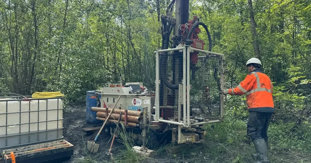
Springfield sits on a plateau where the Mississippian limestone and the overlying cherty clay residuum create one of the most unpredictable foundation environments in the Midwest. The average annual precipitation hovers around 45 inches, feeding a shallow groundwater table that fluctuates dramatically between wet springs and dry late-summer months. That moisture swing, combined with the natural solution cavities riddling the Burlington-Keokuk formation, means a standard soil mechanics study here has to do more than classify material—it has to map void potential and assess collapse risk before the first yard of concrete is poured. In our experience across Greene County, the projects that avoid costly surprises are the ones where the subsurface investigation is designed around the actual karst morphology, not a generic checklist. When the borehole logs start showing red clay with angular chert fragments at 8 to 15 feet, you know you are in classic Springfield residuum, and that material behaves nothing like an ordinary alluvial clay. We often pair deep borings with MASW surveys to image the rock surface and detect voids that standard sampling would miss entirely.
Springfield residuum can lose more than half its bearing capacity when saturated—a fact that surprises engineers unfamiliar with Ozark cherty clays.
Our approach and scope
Local considerations
The risk profile shifts noticeably between downtown Springfield and the growing subdivisions pushing south toward Ozark and Nixa. Downtown, much of the construction is on relatively competent cherty clay with bedrock within reach, but the older fill zones near Jordan Creek conceal buried organics and debris that can cause unexpected settlement. South of the James River, the valleys open up onto alluvial terraces where the soil profile alternates between stiff clay and loose silty sand—and that loose sand is exactly what keeps geotechnical engineers awake at night when they look at the USGS liquefaction susceptibility maps for a New Madrid recurrence. The worst-case scenario is a commercial building sited over a paleosinkhole that was filled with low-density soil seventy years ago and never documented; without a targeted soil mechanics study that includes rock coring and geophysics, that feature stays invisible until the drywall starts cracking. The IBC requires site-specific analysis for karst terrain, and Springfield's building officials are increasingly rigorous about enforcing that requirement on larger commercial projects.
Relevant standards
IBC 2021 (Springfield Building Development Services enforces with Missouri amendments), ASCE 7-22 (Chapter 20: Site Classification Procedure for Seismic Design), ASTM D1586 / ASTM D1587 (Standard Penetration Test and Thin-Walled Tube Sampling), ASTM D2487 (Unified Soil Classification System), ASTM D7012 (Unconfined Compressive Strength of Intact Rock Core), Missouri Department of Natural Resources karst regulations for stormwater and foundations
Complementary services
Geotechnical boring and rock coring program
Mud-rotary drilling through residuum with continuous HQ rock core in the Burlington-Keokuk formation. Each borehole is logged for chert content, clay seams, and void indicators, and selected samples go to the lab for triaxial and consolidation testing when the structural loads demand it.
Geophysical void detection and bedrock mapping
Multi-channel surface wave surveys and electrical resistivity lines across the building footprint. The MASW profile gives us shear-wave velocity for seismic site class, while resistivity anomalies highlight air-filled or clay-filled cavities that drilling alone can miss between boreholes.
Typical parameters
Common questions
How much does a soil mechanics study cost for a commercial lot in Springfield?
For a typical commercial parcel with two to four borings, rock coring, and a full lab suite, you are looking at US$3,150 to US$4,740. The spread depends on depth to competent rock—sites near the James River alluvium can run deeper—and whether geophysics like MASW or resistivity is added. We scope the investigation to match the city's current IBC requirements so there are no surprises during plan review.
Does the city of Springfield require a geotechnical report before issuing a building permit?
Yes. Springfield Building Development Services follows the IBC, which mandates a geotechnical investigation for all structures except certain minor residential projects. For commercial and multi-family buildings, the plan reviewer will expect a sealed report addressing karst hazards, seismic site class, and bearing capacity in accordance with the Missouri-adopted IBC chapter 18.
How do you handle the karst sinkhole risk during a subsurface investigation?
We use a three-step approach: first, a desktop review of Missouri Geological Survey sinkhole maps and historical aerial photos for the site. Second, borings are spaced tighter than standard and carried into competent rock with at least five feet of core recovery. Third, we run electrical resistivity or MASW lines to bridge the gaps between boreholes—voids and clay-filled cutters show up as distinct anomalies that guide any additional targeted drilling.
What seismic parameters are used for foundation design in Springfield?
Springfield sits in the New Madrid Seismic Zone, and ASCE 7-22 governs the design ground motions. The site class—typically C or D depending on the upper 100 feet of material—is determined from shear-wave velocity measurements or SPT blow counts. For Site Class D, the short-period spectral acceleration can be amplified significantly, which directly influences the footing size and the need for ground improvement in loose alluvial soils.